For more than four centuries, humanity has viewed the planet through a remarkably distorted lens. The standard map of the world—ubiquitous in classrooms, textbooks, and digital navigation software—has been fundamentally anchored to a 1569 navigational chart pioneered by the Flemish geographer Gerardus Mercator. While the Mercator projection was a stroke of genius for 16th-century sailors navigating the open seas using straight lines of constant compass bearing, its geometric compromises carry profound modern consequences. By artificially stretching landmasses situated near the Earth’s poles to preserve directional angles, the projection radically distorts true geographic scale. Most notoriously, it swells the appearance of North America and Europe while shrinking landmasses along the equator. Under Mercator’s legacy, Africa—a massive continent spanning over 30 million square kilometers—appears roughly equal in size to Greenland, despite being nearly 14 times larger in reality.
This cartographic illusion is far more than a technical error; it is a persistent visual bias that subtly diminishes the perceived global footprint, geopolitical significance, and cultural vitality of the Global South. However, a monumental shift is underway. On September 4, 2026, the United Nations passed a landmark motion formally endorsing and adopting a new global standard: the Equal Earth Projection. Tabled by representatives from Togo and backed by a coalition of African nations, this decision marks a watershed moment in cartographic history. By replacing the Eurocentric distortions of the past with a scientifically accurate depiction of continental scale, the international community has taken a definitive step toward correcting centuries of geographic misrepresentation.
Yet, this modern debate is merely the latest chapter in an ancient saga. The politics of mapmaking, continental scaling, and geographical representation have ignited fierce intellectual battles since the dawn of classical antiquity. From Herodotus mocking the symmetrical fantasies of early Greek mapmakers to Strabo and Pliny the Elder intertwining landmass dimensions with imperial dominion, humanity has long understood a fundamental truth: the map does not merely reflect the world—it shapes how we perceive power, prestige, and our place within the global order.
Detailed Chronology: From Mercator’s Compass to the UN Breakthrough
To understand the magnitude of the 2026 United Nations resolution, one must retrace the historical trajectory of cartography, tracking how a practical tool for maritime trade evolved into an unshakeable global dogma, and how marginalized nations systematically dismantled it.
1. The 1569 Paradigm: The Rise of the Mercator Projection
In 1569, Gerardus Mercator published his groundbreaking world map, titled Nova et Aucta Orbis Terrae Descriptio ad Usum Navigantium Emendata ("New and Enlarged Description of the Earth Amended for the Use of Navigators"). Designed specifically to aid mariners, Mercator utilized a cylindrical map projection that transformed lines of constant bearing (loxodromes) into straight segments. This allowed sailors to plot courses easily across oceans without constantly recalculating compass headings.
However, translating a three-dimensional spherical globe onto a two-dimensional flat surface requires severe compromises. To maintain navigational utility and local angles (conformal mapping), Mercator sacrificed true area proportions. As latitude increases away from the equator, landmasses expand exponentially. Consequently, regions like Europe, North America, and Russia appear vastly magnified, whereas equatorial zones—home to the vast majority of the human population—are severely compressed. Despite repeated warnings from cartographers over the centuries, the convenience of the Mercator grid cemented it as the default mental image of the world for the industrial and digital ages.
2. Growing Discontent and the Birth of Equal Earth (2018)
By the late 20th and early 21st centuries, the cultural and political implications of Mercator’s distortions could no longer be ignored. Critics, educators, and activists pointed out that projecting a worldview that systematically diminishes equatorial continents inherently reinforces colonial mentalities.
Recognizing an urgent need for an aesthetically pleasing, mathematically sound alternative that preserves true relative sizes, prominent cartographers Bojan Šavrič, Tom Patterson, and Bernhard Jenny joined forces. In 2018, they introduced the Equal Earth Projection. Based on the Winkel Tripel projection framework but modified to ensure equal-area representation, Equal Earth accurately depicts continents and oceans in their true proportional sizes. Crucially, it renders political boundaries, shapes, and landmasses with minimal visual distortion, providing a modern, unbiased window into our planet.
3. The Togo-Led UN Initiative and the September 2026 Resolution
The transition from academic alternative to official global standard culminated on September 4, 2026. Spearheaded by diplomatic representatives from Togo and heavily supported by a unified bloc of African member states operating under civil society banners such as the "Correct the Map" initiative, a comprehensive motion was tabled at the United Nations.
The resolution argued that continuing to rely on a 16th-century European navigational chart as the standard world map actively perpetuates structural inequalities, implicitly signaling that Africa and its peoples are peripheral to global affairs. Following intense debate and broad international consensus, the UN officially endorsed the Equal Earth Projection as a preferred global standard. This landmark vote signaled that the international community was finally ready to discard cartographic relics that fail to reflect geographical reality or the dignity of sovereign nations.
Supporting Context & Metrics: The Scale of Distortion
The mathematical disparity between the Mercator projection and reality is staggering. To fully appreciate why the United Nations’ adoption of the Equal Earth Projection is a historic necessity, one must examine the hard data governing global geography.
The Africa-Greenland Disparity
Greenland’s True Area: Approximately 2.16 million square kilometers.
Africa’s True Area: Approximately 30.37 million square kilometers.
The Mercator Illusion: On a standard Mercator map, Greenland appears visually comparable in size—and sometimes even larger—than the entire continent of Africa.
The Mathematical Reality: Africa is actually 14 times larger than Greenland.
The Distortion Gradient
The distortion on a Mercator map is not uniform; it operates on a logarithmic scale relative to distance from the equator:
Equatorial Regions (0°–15° latitude): Africa, South America, India, and Southeast Asia suffer minimal vertical stretching, rendering them severely understated in visual weight compared to northern latitudes.
Mid-Latitudes (45° latitude): Regions such as the United States, Southern Europe, and China begin to experience noticeable enlargement, making them appear more prominent than equatorial landmasses of similar or superior acreage.
Polar Regions (60°–80+° latitude): Canada, Scandinavia, Russia, and Antarctica undergo extreme ballooning. Greenland and Alaska expand to dwarf entire tropical sub-regions.
By transitioning to the Equal Earth Projection, these mathematical anomalies are neutralized. Continents are restored to their true physical proportions, dismantling an unconscious psychological hierarchy that has subtly influenced human geography education for generations.
Historical Roots: Ancient Debates on Scale, Power, and Representation
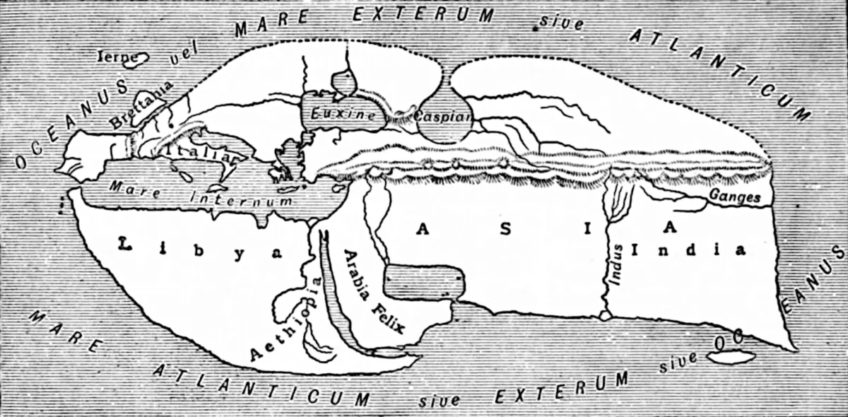
While the 2026 UN resolution addresses a modern political grievance, the underlying tension between cartographic representation and geopolitical power is ancient. Long before Gerardus Mercator put pen to parchment, classical geographers of Greece and Rome were already deeply embroiled in ideological battles over how the Earth should be drawn, measured, and interpreted.
1. Herodotus and the Rejection of Artificial Symmetry
In the fifth century BCE, the pioneering Greek historian and geographer Herodotus launched one of the earliest recorded critiques of contemporary cartography. In Book Four of his Histories, Herodotus expressed open disdain for the mapmakers of his era, mocking their obsession with geometric perfection over empirical reality:
"I laugh when I see that, though many before this have drawn maps of the Earth, yet no one has set the matter forth in an intelligent way; seeing that they draw Ocean flowing round the Earth, which is circular exactly as if drawn with compasses, and they make Asia equal in size to Europe."
Rejecting the tidy, symmetrical world-pictures popular among his contemporaries, Herodotus advanced a radical alternative. Based on his extensive travels and inquiries, he argued that Europe vastly outstripped both Asia and Libya (the ancient term for Africa) in overall scale and breadth, reshaping how the classical world conceptualized the boundaries of civilization.
2. Strabo: Connecting Territorial Scale to Political Might
Writing under the burgeoning shadow of the Roman Empire in the first century BCE, the geographer Strabo approached cartography through a strictly geopolitical lens. In Book 17 of his monumental Geography, Strabo challenged the traditional threefold division of the inhabited world (Europe, Asia, and Libya), noting that Libya fell woefully short of accounting for a full third of the terrestrial sphere:
"Now the writers who have divided the inhabited world according to continents have divided it unequally… Libya lacks so much of being a third part of the inhabited world that even if it were combined with Europe, it would seem not to be equal to Asia. Perhaps it is even smaller than Europe; and in power it is much inferior."
Strabo’s commentary introduced a dangerous precedent: the conflation of geographic scale with political and military dominance. By associating Libya’s comparatively compact size—and its arid deserts and scattered settlements—with an inherent inferiority in power, Strabo established a conceptual framework where visual magnitude equated to civilizational superiority.
3. Pliny the Elder: Cartography as Imperial Celebration
The Roman naturalist and military commander Pliny the Elder made this ideological linkage explicit in his first-century CE encyclopedic work, Natural History. Celebrating the reach of the Roman state, Pliny positioned Europe not merely as a continent, but as the supreme engine of global conquest:
"To begin then with Europe, nurse of the race that has conquered all the nations, and by far the loveliest portion of the Earth, which most authorities, not without reason, have reckoned to be not a third part but a half of the world…"
Through complex and often contradictory mathematical breakdowns, Pliny calculated that Europe constituted well over a third of the Earth, dwarfing Asia and reducing Africa to a fraction of the whole. By placing these measurements directly alongside celebrations of Roman military might, Pliny cemented an enduring imperial trope: that the masters of the world naturally occupy its largest, most expansive, and most visually dominant territories.
Official Statements and Global Reactions
The United Nations’ adoption of the Equal Earth Projection has sent shockwaves through international diplomatic circles, educational institutions, and geographic societies worldwide.
Togolese diplomatic representatives, who championed the motion alongside civil society groups like the "Correct the Map" coalition, issued a joint statement following the September 4 vote:
"For centuries, maps have been weaponized as silent arbiters of importance. By clinging to a 1569 navigational tool that reduces entire continents to footnotes while inflating northern territories, global education has implicitly endorsed a hierarchy of human value. The UN’s endorsement of the Equal Earth Projection is a historic correction—not just of geometry, but of historical dignity. Africa is no longer marginalized by design."
Cartographic societies and educational bodies have similarly praised the resolution. Dr. Bojan Šavrič, one of the co-creators of the Equal Earth Projection, expressed profound gratitude during a press briefing following the announcement:
"When Tom Patterson, Bernhard Jenny, and I developed Equal Earth in 2018, our goal was simple: to provide a modern, mathematically sound map that tells the truth about our planet’s surface. We never imagined it would become the foundation for a global realignment at the United Nations. Cartography is a language of communication; ensuring that language is honest is vital for international equity."
Educational authorities across the globe have begun drafting frameworks to phase out Mercator-based maps in public school curricula by 2030, ensuring that the next generation of students grows up viewing a scientifically accurate representation of our shared home.
Future Outlook: A New Cartographic Era
The formal adoption of the Equal Earth Projection by the United Nations marks the end of an era of unchallenged cartographic Eurocentrism and the beginning of a more balanced global perspective. As schools, international organizations, and digital cartography platforms transition away from the Mercator grid, the practical implications will ripple across society.
Educational Reform: Geography textbooks worldwide will feature proportional maps, eliminating the subconscious conditioning that minimizes the Global South. Climate change data, demographic studies, and resource distribution models will be analyzed through an unskewed lens, leading to more accurate geopolitical planning.
Digital Mapping Evolution: Major tech companies and geographic information system (GIS) providers face mounting pressure to incorporate equal-area projections as default options for global data visualization, moving beyond the limitations dictated by 16th-century marine navigation.
Cultural Reclamation: As historical debates from Herodotus, Strabo, and Pliny remind us, maps are deeply cultural artifacts. The shift to Equal Earth serves as a powerful reminder that visual representation matters—that the physical dimensions of a continent should mirror its cultural, economic, and human vitality on the global stage.
Ultimately, the UN’s historic decision proves that maps are not static monuments of science, but dynamic tools that must evolve alongside humanity’s pursuit of truth, equity, and global justice.